
Over ten inches of rain fell in the western part of the Richmond metro area last weekend, surprising residents and triggering evacuations near two local dams. Northern Prince George County also received eight to ten inches of rainfall.
One volunteer weather spotter reported 11.19 inches of rain at a spot in western Chesterfield from Friday night through Sunday morning. Meanwhile, about 15 miles away, the Richmond International Airport received less than four inches of rain.
Mike Montefusco, meteorologist at the National Weather Service’s Wakefield office, said the rain was part of a typical August weather pattern. Montefusco described several rounds of rain hitting the area over the past five days. Then, a stalled frontal system and an area of low pressure slowly contributed rain to the already saturated region. Montefusco expects that pattern to continue.
“We are locked up in a pattern where we are going to have very slow-moving fronts moving through the area,” Montefusco said. “As is typical for this time of year, the fronts really don’t have a lot of force to them in terms of pushing through the area and quickly clearing out.
Montefusco expects that pattern to continue and with the ground already saturated, flood risks continue.
At a press conference Monday, Chesterfield County fire chief Loy Senter said the flooding on Friday and Saturday was at historic levels.
“It was the most serious flooding we’ve had in Chesterfield in recent memory,” he said.
Multiple roads are closed due to the flooding. The Chesterfield Observer reported that local police responded to at least one person trapped on a road by the flooding.
Chesterfield utilities director George Hayes said the flooding inundated two of the county’s three water pumping stations, but that water quality was not compromised. Nevertheless, the county is now under an emergency water restriction while they focus on bringing one of the pumping stations back on line. Hayes expects that to take days, not weeks, and will be able to lift the restriction then. The other facility will take longer. Its basement was flooded with 11 additional feet of water above ground.
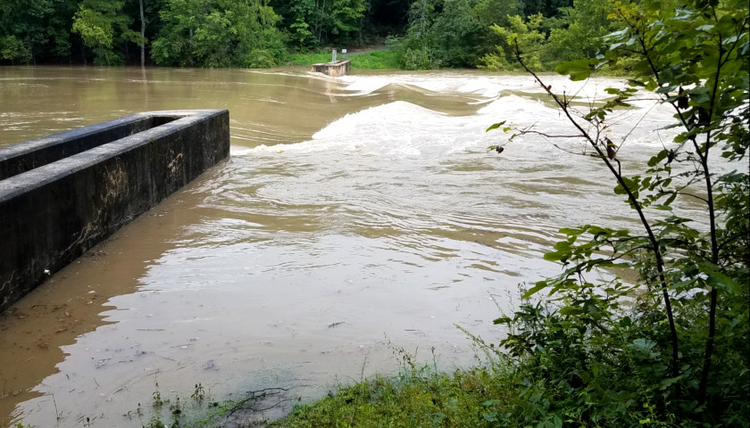
Hayes said the local dams were not damaged and nearby residents have already returned to their homes since flow levels over the dams are normal. During the evacuation on Saturday, one dam which normally sees six inches of flow saw almost five-and-a-half feet of flow.
Pocahontas State Park, located in central Chesterfield, experienced extensive damage. The park’s lake rose close to 20 feet, washing away its rental boat facility and flooding two parked cars. A footbridge across the lake suffered damage to its handrails, and all of the park’s mountain bike trails are closed. Assistant park manager Kevin Faubion said the bridge will be reopened soon, but other damage will take longer to repair. Faubion does not expect the park’s boat rental service to reopen this season.
“I believe the final count was around 9.6 inches of rain,” Faubion said. “As far as I know, that’s never happened before.”
Faubion said the flooding surprised park staff.
Normally they are able to lower lake water levels when expecting rain, including during Hurricane Isaias two weeks ago. That did not happen before this rain.
“It definitely snuck up on us,” Faubion said. “The forecast we got about this rain was that it was going to be about an inch and a half.”
– – –
Eric Burk is a reporter at The Virginia Star. Email tips to [email protected].
About the Headline Photo: Known to locals as the Swift Creek Lake dam, Pocahontas State Park Assistant Manager Kevin Faubion took this picture on Saturday, August 15.